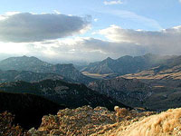
The Chief Joseph Scenic Highway runs through Sunlight Basin. It is
kept open all year, though winter storms close it periodically.
The highway crosses into Sunlight Basin at Dead Indian Pass, elevation 8070 feet.
There are conflicting stories about the source of the name, Dead Indian.
The most popular version is that the name comes from an 1878 skirmish between
General Miles and a group of Bannock Indians where one Indian was killed. In
1877 Chief Joseph and his Nez Perce traveled through Sunlight Basin during their
attempt to escape from the U.S. Cavalry.
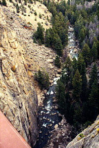
The bridge over the Sunlight Gorge, which is 1,200 feet deep, is the highest bridge in Wyoming.
Sunlight Basin is home to a substantial population of Grizzly bears. Wolves from Yellowstone have recently moved into the area.