Located in northwestern Wyoming, the Bighorn Basin is formed by the
Bighorn Mountains to the east, the Owl Creek Mountains to the south,
and the Absaroka Mountains to the west.
The Bighorn Basin is vast, larger than Connecticut and Delaware
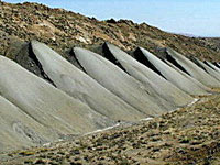
combined. It is arid; most of the Basin receives between six and 10
inches of precipitation annually. Irrigated communities create small
corridors of greenery in the arid badlands.
Archaeological evidence indicates human habitation of the Basin goes back 10,000 years.
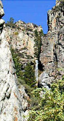
Difficult terrain made the Basin one of the last parts of Wyoming
to be settled. Summits in the Bighorn Mountains and the Absaroka
Mountains extend over 13,000 feet.
John Colter came through the area in 1807. The first baseball game
in the Basin was staged in 1870 by a mining expedition camped on the
Greybull River.
The four counties which contain the Basin cover 14,323 square miles. Their total population is approximately 42,000 people.